
How LiDAR Mapping and Topographic Surveys Work Together
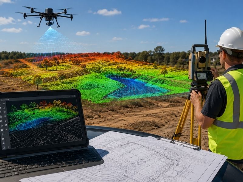
Lidar mapping sounds like something out of a sci-fi movie, but it’s just a laser doing math. Fire millions of light pulses at the ground, time how long they take to bounce back, and you get a height for every point they hit. Builders use lidar mapping to see a site’s shape before anyone breaks ground.
Lidar can’t do the job alone, though. A topographic survey fills in the gaps lidar misses, like the exact elevation a permit office needs. Use both together, and you get a site plan that holds up to inspection and to Tampa Bay’s flat, flood-prone ground.
What LiDAR Mapping Actually Does
Lidar stands for light detection and ranging. A plane, drone or vehicle carries a laser scanner over a site. The scanner fires up to a few hundred thousand pulses a second at the ground below.
Each pulse bounces back, and the scanner records how long the trip took. Multiply that time by the speed of light, cut it in half, and you get the distance to whatever the pulse hit. Stack millions of these points together and you get a 3D map of the land. Surveyors call this a point cloud.
Lidar covers ground fast. A drone can scan dozens of acres in an afternoon. That speed makes it a strong first step for any site that’s too big or too rough to walk every inch of it. It also picks up the general slope direction across a large parcel, which matters once stormwater design starts.
What a Topographic Survey Adds That LiDAR Can’t
A topographic survey uses ground equipment, like a total station or GPS rover, to measure exact points on a site. A surveyor walks the property and records elevation, property lines and features like trees, fences and utility covers.
Lidar gives you the overall shape of a site. A ground survey gives you the legal, stamped numbers a permit office will actually accept. Cities want surveyed elevations on the final plan, not laser estimates, even good ones.
Ground surveys also catch small details lidar can miss. A manhole cover, a low spot in a backyard or a buried utility marker might not stand out in a point cloud. A surveyor walking the site will spot it, measure it and tie it back to a known benchmark so every number on the plan lines up.
Why Tampa Sites Need Both Methods
Most of Tampa sits at or above 7 feet of elevation, based on the city’s own data. That sounds high enough, until you remember how flat the ground stays for miles in every direction. Flat land like this hides drainage problems that show up fast once a storm rolls through.
Flat Land Hides Drainage Problems
A site can look level to the eye and still have a low spot that floods every storm. Lidar picks up these small dips across a whole property. A ground survey then confirms the exact elevation at the spots that matter most, like a building pad or a stormwater inlet.
Flood Zone Rules Demand Precise Elevations
Hillsborough County and FEMA both require surveyed elevations for flood zone permits. A flood elevation certificate has to come from a licensed surveyor, not a lidar dataset alone. Skip the ground survey, and the City of Tampa’s Construction Services Center will send the permit right back.
Storms like Hurricane Milton are a reminder of why this matters. Heavy rain exposes every low spot a rough lidar pass might miss, and a surveyed elevation is what protects a project once the water shows up.
Where LiDAR Data Falls Short
Lidar isn’t perfect. Tree cover, water and shiny surfaces can throw off the readings.
A few common problems:
- Thick tree canopy blocks some laser pulses from reaching the ground.
- Standing water absorbs the laser signal and gives a bad return.
- Older or low-density lidar datasets miss small features like curbs and drainage swales.
- Public lidar data can be a few years old, and Tampa keeps changing fast.
None of these problems make lidar useless. They just mean you shouldn’t treat it as the final word on a site’s elevation.
Combining LiDAR and Ground Survey Data for Site Plans
The smart approach uses lidar first and a ground survey second.
Start with lidar data to get a fast look at the whole site. Spot the rough high points, low points and drainage paths. Then send a survey crew to confirm elevations at the spots your design depends on, like building corners, retention pond edges and connection points to public utilities.
This two-step process saves time without cutting corners. You’re not surveying every square foot by hand, and you’re not betting a permit on laser data alone. For a Tampa site, that combination is often the difference between a smooth permit review and a plan that bounces back with comments.
Lidar gets you moving fast. A ground survey gets you a permit. Use both, and your site plan won’t get sent back for missing data.
Frequently Asked Questions
What Is LiDAR Mapping Used for in Land Development?
Builders use LiDAR mapping to get a fast and wide view of a property’s terrain before design work begins. It helps identify slopes, drainage patterns, and general elevation changes across the site.
How Accurate Is LiDAR Compared to a Ground Survey?
LiDAR provides highly detailed elevation data, but a ground survey offers greater accuracy at specific locations. Permit agencies and regulatory authorities typically require surveyed measurements for flood zones, boundary work, and final grading.
Can LiDAR Replace a Topographic Survey?
No. LiDAR data can miss smaller features such as manholes, drainage structures, low spots, and survey monuments. A topographic survey supplements LiDAR data and provides the precise measurements needed for engineering design and permitting.
Why Are Topographic Surveys Important for Flood Zone Properties?
Flood zone requirements from FEMA and local agencies often require elevation information certified by a licensed surveyor. LiDAR data alone does not satisfy these requirements or replace an elevation certificate.
How Long Does a LiDAR Survey Take Compared to a Ground Survey?
A drone equipped with LiDAR can collect data across dozens of acres in a matter of hours. A traditional ground survey usually takes longer because survey crews must physically measure key points and verify important site features.