
How to Read a Plat of Survey
A property can look simple at first glance. The lot seems wide enough. The driveway looks clear. There appears to be plenty of room for a pool, garage, or home addition.
Then construction plans begin. Suddenly, problems show up.
The setback cuts into the build area. A utility easement blocks part of the yard. The fence line does not match the real property boundary.
That is why a plat of survey matters before you build.
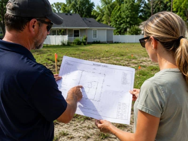
Many property owners receive a survey during a purchase but never really look at it. Others glance at the drawing and feel confused by the lines, numbers, and symbols. However, learning the basics can help you avoid expensive mistakes later.
A plat of survey shows the true layout of your property. It helps you understand where you can build, what limits exist, and what issues could affect future construction.
What Does a Plat of Survey Show?
A plat of survey shows the legal layout of a property, including boundaries, lot dimensions, easements, structures, setbacks, and utility areas. Property owners often use it before building pools, additions, fences, or driveways to avoid permit issues, boundary disputes, and construction mistakes.
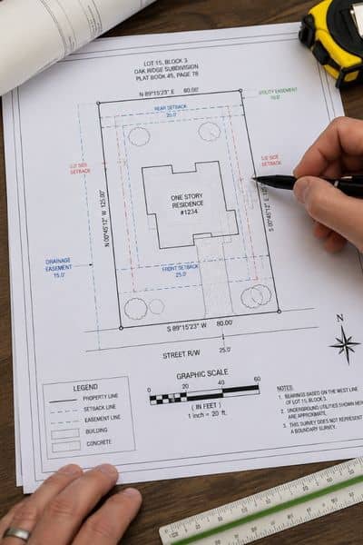
A plat of survey is a detailed drawing of a property. It shows the size and shape of the lot along with important site features.
The survey usually includes:
- property lines
- lot dimensions
- buildings
- driveways
- fences
- easements
- setback lines
- utility areas
In Tampa, property owners often need a survey before:
- building a pool
- adding a room
- widening a driveway
- installing a fence
- building a detached structure
Without a clear survey, contractors and homeowners may guess where things belong. That creates risk right away.
How Property Lines Affect Construction Projects
Property lines determine where construction can legally happen on a lot. A plat of survey helps property owners avoid building beyond legal boundaries, which can lead to disputes, permit problems, fines, or expensive removal of structures like fences, patios, and driveway extensions.
The first thing to review on a plat of survey is the property boundary.
Many people assume the existing fence marks the correct line. That is not always true. In fact, some fences sit several feet away from the real boundary. Others cross onto nearby property without the owner realizing it.
The survey shows the legal property shape using measurements and corner markers. These lines define the actual limits of the lot.
Before building anything, make sure you understand:
- where the side boundaries sit
- where the rear property line ends
- how wide the lot really is
- whether the lot shape changes near the back
This matters because even a small mistake can create large problems later. A patio, shed, or driveway extension built outside the property line may need removal.
Understanding Setback Lines Before You Build
Setback lines create required space between structures and property boundaries. In Tampa, setback rules affect pools, garages, additions, and detached buildings. A plat of survey helps homeowners understand buildable space before construction begins and reduces the risk of redesigns or permit delays.
Next, look for setback lines on the survey.
Setbacks are required spaces between structures and property lines. Tampa building rules use setbacks to keep homes safely spaced apart.
For example, your property may require:
- front setbacks
- side setbacks
- rear setbacks
These limits reduce the buildable area of the lot.
This surprises many homeowners. The yard may look large enough for a project, yet the setback rules shrink the usable space.
Pools often run into setback issues. So do home additions and detached garages.
Before spending money on design plans, check how much room remains inside the setback lines. Otherwise, you may need to redesign the project later.
What Easements Mean on a Plat of Survey
Easements give utility companies or other parties limited rights to part of a property. A plat of survey shows drainage, utility, and access easements that may limit where structures can be built on residential or commercial lots.
Easements cause confusion for many property owners.
An easement gives another party limited rights to part of the property. Utility companies often use easements to access underground lines or drainage systems.
The survey may show:
- drainage easements
- utility easements
- access easements
These areas can limit where you build.
For example, you may not place a permanent structure over a drainage easement. In some cases, utility crews may need access to that area later.
Many utility easements remain active even if no visible equipment appears on the property. Because of that, property owners should never assume the area is free to build on.
Tampa properties often contain drainage features because heavy rain and stormwater management remain major concerns throughout the area.
That is why easements deserve careful attention before construction starts.
Check Existing Structures and Improvements
The survey also shows structures already located on the property.
This usually includes:
- the house
- driveway
- fences
- sidewalks
- retaining walls
- patios
These details help you understand how much open space remains for future improvements.
For example, a homeowner may want to expand the driveway. However, the survey could reveal that the current layout already sits close to the property line or easement area.
Likewise, an addition may appear possible until the survey shows limited remaining build space behind the home.
The drawing helps turn rough ideas into realistic planning.
Why Elevation Notes Matter
Elevation notes help identify drainage concerns, flood-prone areas, and grading challenges on a property. In Tampa, elevation information on a plat of survey can affect stormwater flow, construction planning, insurance requirements, and future site improvements.
Some surveys include elevation information.
This matters in Tampa because parts of the area deal with drainage concerns and flood risk. Even small elevation changes can affect water movement around a property.
Low areas may collect water during heavy rain. Certain lots may also require extra grading work before construction.
Flood-prone areas near Tampa Bay may also require additional elevation review before construction projects receive approval.
You do not need to become an engineer to understand the basics. Still, pay attention if the survey notes:
- flood zones
- drainage paths
- low elevations
- retention areas
These conditions can affect future permits, insurance costs, and site design.
Common Plat of Survey Mistakes Homeowners Make
Many homeowners misunderstand surveys by relying on fence lines, outdated maps, or old surveys. A current plat of survey helps prevent construction mistakes, easement conflicts, and boundary problems before building projects begin.
Many construction problems begin with simple survey misunderstandings.
One common mistake involves measuring from the wrong line. Some people measure from fences or sidewalks instead of legal boundaries.
Others ignore easement labels because they seem unimportant at first.
Some homeowners also rely on online property maps. Those maps help with general viewing, but they do not replace a professional survey.
Another issue happens when owners use an old survey for a new project. Property conditions can change over time. New fences, additions, or utility work may affect the site layout.
That is why updated information matters before major construction begins.
When Should You Order a New Plat of Survey?
Property owners should order a new plat of survey before major construction, permit applications, land purchases, driveway expansions, fence installations, or resolving boundary disputes. Updated surveys provide accurate site information that helps avoid delays and costly changes later.
A recent plat of survey can help before:
- building a pool
- adding a garage
- expanding a driveway
- installing a fence
- buying vacant land
- resolving a neighbor dispute
- applying for permits
Even if you already have an older survey, a new one may provide more accurate information for current conditions.
That extra clarity can prevent delays and costly changes later.