
Property Line Markers When a Corner Falls Beneath New Pavement
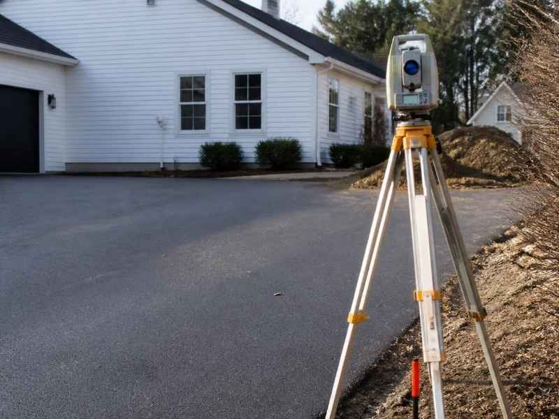
New pavement can hide a corner in minutes. A paving crew lays asphalt, and the marker is gone. That small pin held the edge of your property. Now it sits buried under a hard surface. A surveyor can still find where it belongs.
Property line markers are the pins and monuments that fix your corners. A monument is a physical marker set at a property corner. These markers show where your land legally ends. Lose one, and the corner is not lost with it.
You don’t need to panic if a corner gets covered. Surveyors deal with hidden corners often. They use records and field evidence to bring the point back. This guide shows how that works and what to do next.
Property Line Markers That Become Covered During Paving Work
Paving is a common way corners disappear. A new driveway, road, or parking lot goes in. The crew grades the ground and lays the surface. Any pin in the path gets buried or destroyed.
Property line markers sit low to the ground by design. Many are iron rods or pipes driven near flush. Some have a cap with the surveyor’s number. A layer of asphalt or concrete hides them fast.
This happens a lot on growing sites. Tampa sees steady building and repaving work. Corners near the road edge are at high risk. So are corners along shared drives and lot lines.
A covered corner is not a legal loss. The corner still exists in the eyes of the law. Its spot is fixed by the deed and the record. The marker is just the physical proof on the ground.
Still, a buried corner causes real problems. You may need it for a fence, an addition, or a sale. Digging blind can miss it or damage it. A surveyor is the safe way to get it back.
Survey Evidence Used When an Original Corner Is No Longer Visible
A surveyor rebuilds a hidden corner from evidence. Evidence is the proof used to place a point. It comes from records and from the field. Good evidence leads to a firm, defensible corner.
Record evidence comes from paperwork. The surveyor pulls deeds, plats, and past surveys. A plat is a map that shows how land was divided. These papers give measurements to the corner.
Field evidence comes from the ground itself. The crew looks for clues near the buried spot, such as:
- Other markers still in place nearby
- Old fence lines, walls, or pipes
- Marks noted in a prior survey
- Points held by neighbors’ corners
The surveyor ties these clues together. They measure from known points to the missing one. This is where math and records meet real ground. The goal is to place the corner right where it was.
Sometimes the pin is only just below the surface. A metal detector can find an iron marker under thin cover. If the pin survived, that’s the best proof of all. If it didn’t, the record and nearby evidence guide the reset.
Pavement, Curbs, and Other Improvements Around a Hidden Corner
Pavement changes the site around a corner. It hides the ground and adds new edges. Those new edges are not property lines. A curb or a driveway rarely sits right on the line.
People often confuse an improvement with a boundary. A neighbor may treat the pavement edge as the line. That guess can be off by inches or feet. Only a survey shows the true corner under it all.
Curbs, aprons, and slabs add more layers to sort through. Each was built to a plan, not to your property line. A surveyor reads past what they see on top. They trace the corner to its recorded spot.
This matters for planning any new work. A fence or wall built to the pavement edge can cross the line. That can spark a dispute or a forced redo. Confirm the real corner before you build near covered ground.
Utilities can sit near these corners too. Drainage inlets and pipes often run along road edges. Digging for a corner needs care around them. A surveyor works to find the point without harm.
Methods for Reestablishing a Corner Without Relying on Surface Markings
Reestablishing a corner means setting it back in place. The surveyor does this by measurement, not by guesswork. They rely on records and known control, not on the pavement. This keeps the corner honest and provable.
The crew starts from points they trust. These are other markers or control points nearby. Control points are fixed spots with known positions. From there, they measure to the missing corner.
Modern tools make this precise. Surveyors use GPS gear and total stations to measure. A total station is an instrument that measures angles and distances. Together these tools place the corner within a tight range.
Once the spot is found, the crew sets a new marker. They may core a small hole through the pavement to place it. The new marker is tagged with the surveyor’s number. This gives you a fresh, visible corner again.
The surveyor then records the work. They note how the corner was reset and from what evidence. This record protects the corner for the future. Methods can vary by site and local rules, so ask what your job needs.
Future Site Work After Property Line Markers Are Documented Again
A reset corner sets you up for what’s next. With the point back, you can plan with confidence. Fences, additions, and sales all lean on firm corners. Fresh markers make each step easier.
Keep the new survey in your records. Store the map and the field notes somewhere safe. You may need them years later for a project. A good record saves time and money down the road.
Protect the new markers during any work. Tell your contractor where each corner sits. Ask them to avoid burying or breaking the pins. A little care keeps your corners visible longer.
Think ahead if more paving is coming. If you plan to repave, mark the corners first. A surveyor can set a witness point off to the side. A witness point is a reference set away from the true corner. It helps you find the corner again after new work.
Plan your survey timing with care. Confirm your needs early if a sale, permit, or build depends on the corners. Requirements can vary by project, lender, and municipality. A licensed surveyor can help you set and protect your property line markers before the next phase begins.
Frequently Asked Questions
Can a surveyor find a property corner buried under pavement?
Yes, a surveyor can recover a corner hidden under pavement. They use deeds, plats, past surveys, and nearby field evidence to place it. Tools like GPS and a metal detector help locate or reset the point. The corner still exists legally, even when the marker is covered.
Is the edge of my driveway the same as my property line?
Usually no, a driveway or pavement edge is not your property line. These surfaces are built to a plan, not to your legal boundary. The true line can sit inches or feet away from the pavement. Only a survey can show where your real corner falls.
Should I dig for a buried marker myself?
It’s better to let a surveyor handle it. Digging blind can miss the pin or damage it. You could also hit a nearby utility line by accident. A surveyor finds the spot with records and tools, then sets a clean marker.