
Boundary Survey vs. Property Line Dispute: Know the Difference
You bought the property. You have the deed. You think you know where your land ends.
Then a neighbor puts up a fence three feet into your yard, and suddenly nothing feels certain anymore.
This happens more than most developers expect. And the confusion usually starts with one missing step: no boundary survey was done before the problem started.
A boundary survey and a property line dispute are not the same thing. One prevents problems. The other is what happens when prevention gets skipped. If you’re developing land, buying lots, or planning any construction, knowing the difference saves time, money, and legal headaches.
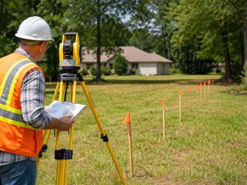
What Is a Boundary Survey?
A boundary survey is an official measurement of a property’s legal edges. A licensed surveyor goes to the site, reviews recorded deeds and plat maps, locates existing markers, and confirms exactly where the property lines are.
The result is a signed, sealed document that shows:
- The property’s corners and dimensions
- Any encroachments from neighboring structures
- Easements that cross the land
- Setback lines that affect where you can build
This document is legally recognized. Courts accept it. Lenders require it. Title companies use it. It’s the clearest answer you can get to the question “where does my property actually start and stop?”
When Developers Need a Boundary Survey
Boundary surveys aren’t just for homeowners with fence arguments. Developers need them at several points:
- Before purchasing a parcel to confirm you’re getting what the listing describes
- Before filing for permits to avoid setback violations
- Before construction begins to position structures correctly
- Before subdividing land to create accurate lot lines for new parcels
Skipping this step early almost always costs more later. A misplaced building foundation is not a cheap fix.
What Is a Property Line Dispute?
A property line dispute is a conflict between two or more parties about where a boundary sits. It usually involves neighbors, but it can also involve municipalities, utility companies, or previous owners.
Common causes include:
- Fences built in the wrong location
- Driveways or structures that cross the legal line
- Conflicting legal descriptions in older deeds
- Survey markers that were moved or destroyed
Disputes can stay informal, meaning two neighbors arguing over a fence. Or they can go to court, which gets expensive and slow fast.
How Disputes Start Without a Survey
Most property line disputes share a common origin: someone assumed.
They assumed the old fence was on the line. They assumed the lot dimensions matched the listing. They assumed nothing had changed since the last survey in 1987.
Without a current boundary survey, assumptions fill the gap. And assumptions are not defensible in court.
How a Boundary Survey Resolves a Dispute
Once a licensed surveyor produces a current, sealed boundary survey, the guesswork ends. The document shows the legal line based on recorded instruments and physical evidence.
That doesn’t mean the other party has to accept it immediately. But it does mean you have something to stand on. Without one, both sides are just arguing opinions.
Courts and mediators give significant weight to a licensed surveyor’s findings. An outdated survey or verbal account carries far less.
What the Survey Shows That Opinions Don’t
- Exact measurements from recorded monuments
- A comparison of current conditions against original plat records
- Any discrepancies between what’s on the ground and what’s on paper
- Professional certification from a state-licensed surveyor
That last point matters. Only a licensed surveyor can legally certify property boundaries in most states. A contractor’s measurement or a GPS reading from a phone doesn’t carry the same legal weight.
Boundary Survey vs. Property Line Dispute: The Real Difference
Think of it this way. A boundary survey is something you order. A property line dispute is something that happens to you.
One is a tool. The other is a problem.
The survey comes first. The dispute comes when the survey didn’t.
A boundary survey is a professional service with a fixed scope, a defined deliverable, and a licensed signature at the bottom. A property line dispute has no fixed scope. It runs as long as both sides keep disagreeing, and the costs grow with every week it stays unresolved.
Developers who work with boundary surveys before breaking ground aren’t just following best practice. They’re cutting off a category of risk before it has a chance to start.
Cost Comparison Without the Numbers
The survey has a one-time fee. The dispute has legal fees, delays, potential redesigns, and in some cases, structures that have to come down. No survey cost comes close to what a mid-construction boundary dispute can pull out of a project budget.
Why Developers Should Act Before the Dispute, Not After
Developers move fast. Timelines are tight. It’s tempting to push surveys later in the process.
That’s where expensive mistakes happen.
A boundary dispute mid-construction can halt a project. A permit rejection due to a setback violation can delay a closing. A title issue traced back to unclear lot lines can kill a deal entirely.
Ordering a boundary survey early is a small cost compared to any of those outcomes. It also gives you clean data to work with from the start, so your architects, engineers, and contractors are all building from accurate information.
Frequently Asked Questions
Do I need a new boundary survey if one was done 10 years ago?
Yes. Property conditions change. New structures, utility work, and updated records can all affect accuracy. A current survey reflects current conditions and current standards.
Can a property line dispute be resolved without going to court?
Often, yes. A licensed surveyor’s findings give both parties a factual baseline. Many disputes settle once a certified survey establishes the actual line.
Does a boundary survey show easements?
Yes. A boundary survey typically identifies recorded easements that cross or border the property, which is important to know before planning any construction.
Is a boundary survey required to get a building permit?
Requirements vary by jurisdiction. Many permitting offices require survey data to verify setback compliance before approving construction on a lot.
What’s the difference between a boundary survey and a location survey?
A boundary survey establishes legal property lines with full research and physical verification. A location survey shows where existing improvements sit relative to the lot, but it doesn’t carry the same legal weight as a full boundary survey.